Thinking about paying a premium for an Encinitas oceanfront or ocean-view home? You are not alone. The sound of the surf and a daily sunset can be worth a lot, but the factors that create value on this coastline are specific, technical, and sometimes hidden in the details. In this guide, you will learn what truly drives price and long-term value in Encinitas, how to weigh the trade-offs, and the steps to take before you write an offer. Let’s dive in.
What sets prices in Encinitas today
Encinitas is a high-end coastal market where recent citywide indices have hovered around a median of roughly $1.8 million to $1.9 million. Within that backdrop, oceanfront and top-tier ocean-view properties command a clear premium over comparable inland homes. Academic studies that isolate view quality find a wide range of premiums, from the mid-teens to near 50 to 60 percent for the very best, unobstructed views in some markets, which is a useful benchmark rather than a single number for Encinitas. For street-level accuracy, you will still want recent local comps because month-to-month dynamics and inventory can shift negotiating power.
For your personal calculus, remember this: view quality, lot constraints, and risk controls explain most of the spread between two similar homes with different price tags.
Bluff stability and erosion risk
Bluff stability is the first filter for any Encinitas oceanfront property. Regional coastal-hazard modeling used in San Diego County planning explicitly simulates wave run-up, storm flooding, and long-term cliff retreat across different sea-level scenarios. These models, widely referenced in local reviews, inform where a home can safely sit and how to calculate setbacks. You can read more about this approach in a peer-reviewed overview of hazard modeling for Southern California coasts.
Local history also shows why this matters. Encinitas has experienced episodic bluff collapses, including a fatal blockfall near Grandview in 2019, which shapes public risk perception and policy. Those events are reminders that geologic hazards are not theoretical along this shoreline.
City code and the Local Coastal Program add the permitting teeth. For bluff-top sites, you should expect a site-specific geotechnical report, conservative factor-of-safety requirements, and baseline setbacks that often start at 40 feet. On smaller lots, those setbacks can significantly shrink the buildable footprint.
What this means for value:
- Buildable area often decreases with stricter setbacks, which can limit future expansions and reduce the max livable square footage on a bluff-top parcel compared with a same-size inland lot.
- Buyers often price in uncertainty about future bluff retreat, seawall limits, or forced-removal conditions. That risk discount can lower bids even when a structure looks stable today.
- The permanence of the view matters. If the long-term safety of a home or yard depends on shoreline armoring that may not be permitted later, many buyers adjust their willingness to pay.
Helpful sources:
- Review hazard modeling context in this journal overview of coastal processes and cliff retreat in Southern California.
- Read reporting on the 2019 Grandview bluff collapse to understand local geology and community response.
- Check Encinitas’s Coastal Bluff Overlay standards for setbacks and geotechnical requirements.
Beach access and width
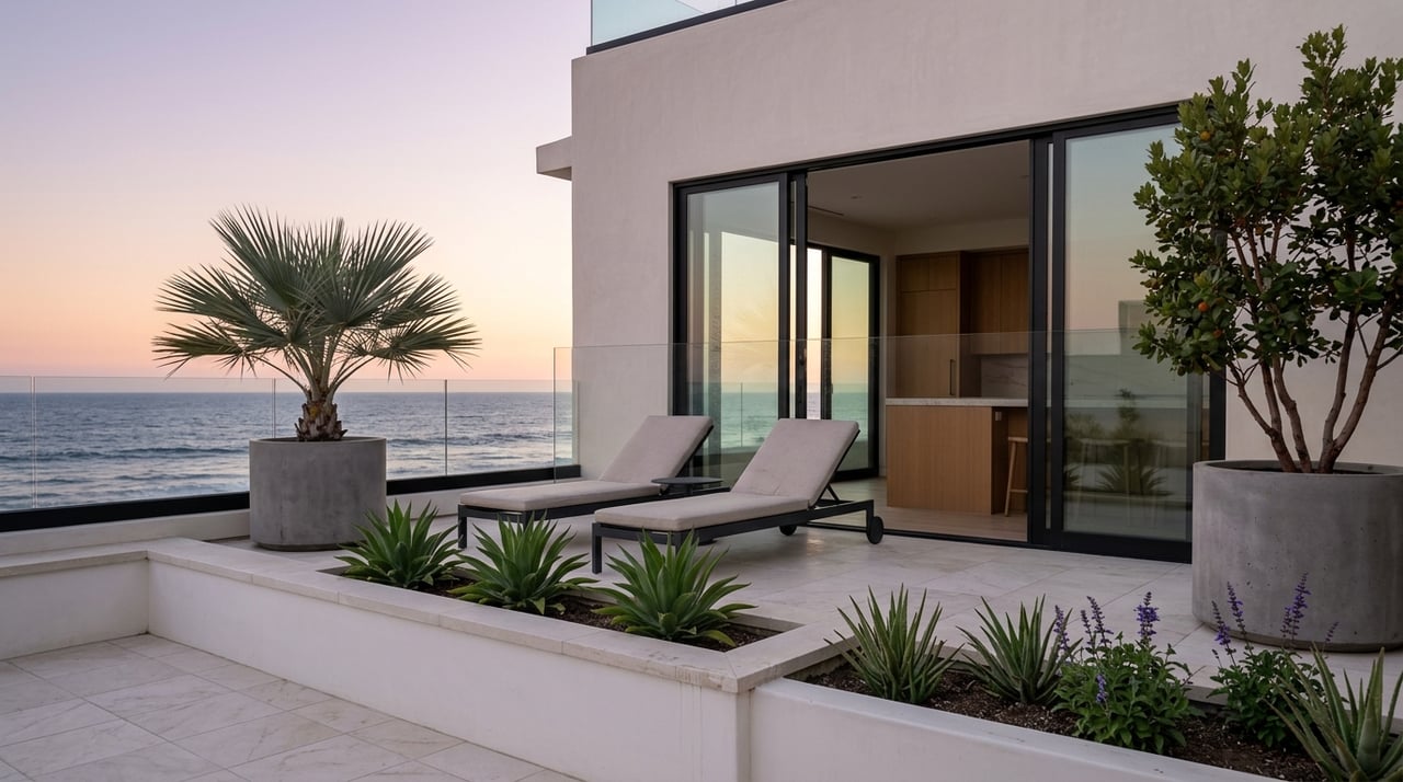
Access to the sand and the quality of the beach below a bluff can swing value meaningfully. Encinitas has multiple public access points, including Moonlight, Swami’s, Grandview, Beacon’s, and D Street. If you prefer easy, day-to-day use of the beach, proximity to a formal accessway and a broader, walkable beach often justifies a higher premium.
Beach width changes over time. In 2024, a regional nourishment project placed about 340,000 cubic yards of sand along parts of the North County shoreline, temporarily widening some beaches and improving near-term amenity value. These efforts help, but they are periodic and do not eliminate bluff-retreat risk.
What this means for value:
- Homes with convenient, stable access and a wide, walkable beach often command higher premiums.
- Narrow or debris-prone beaches under a bluff reduce day-to-day enjoyment and can increase perceived hazard during winter storms, which may dampen demand.
Learn more about public beaches and access points on the City’s beaches page, and see local reporting on recent nourishment activity.
Permitting and approvals
Development and significant remodels in the coastal zone typically require a Coastal Development Permit. On bluff-top sites, that process almost always includes a geotechnical investigation, setback verification, and potential appeal to the California Coastal Commission. The City’s code also limits new shoreline armoring unless an existing principal structure is in imminent danger and no feasible alternatives exist. When armoring is allowed, mitigation or conditions can apply.
What this means for value:
- CDPs add time, consultant costs, and discretionary risk to the equation, which some buyers discount in their offer price.
- Permit conditions like waivers of future armoring or mandatory removal if a structure becomes unsafe can narrow the future buyer pool and affect resale.
You can review Encinitas’s Coastal Bluff Overlay and CDP standards in the municipal code.
Insurance, lending, and disclosures
Financing and carrying costs change the math on coastal properties. Lenders must determine whether a mortgaged property sits in a FEMA Special Flood Hazard Area. If it does, flood insurance is typically required for the life of the loan. Coverage is available through the National Flood Insurance Program and private markets, but costs vary and NFIP has coverage caps.
California law also requires sellers to provide a Natural Hazard Disclosure and other standard disclosures that flag whether a property lies in flood, landslide, seismic, or other mapped hazard zones. These documents are standard in Encinitas transactions and guide your due diligence.
What this means for value:
- Homes in SFHAs or that require expensive private flood policies carry higher recurring costs, which can reduce affordability and compress the buyer pool.
- Properties that are outside SFHAs and have accessible, reasonably priced coverage tend to be easier to finance and sell.
For reference, review lender flood-insurance requirements and California’s NHD statute.
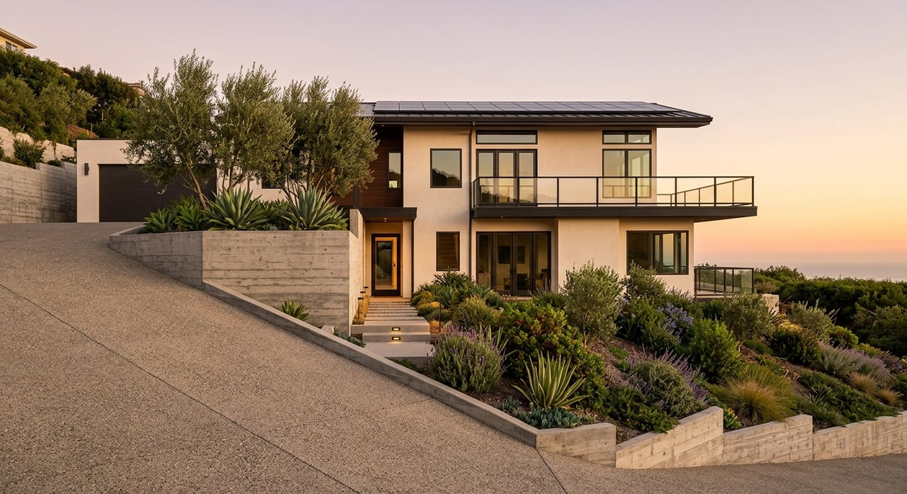
Lot, orientation, and view permanence
Not all views are equal. Unobstructed, west-facing, panoramic views with strong sunset exposure typically command higher premiums than angled, partial, or peekaboo views. That premium grows when your view is unlikely to be blocked by future development, which depends on local height limits, adjacent parcel potential, and any public view-corridor protections.
Buildable area also matters. On bluff-front parcels, setbacks, easements, and slope restrictions often shrink the permitted building envelope. A slightly smaller lot with a secure footprint and protected views can outperform a larger lot whose usable square footage is constrained.
A useful backgrounder on view premium ranges comes from a widely cited hedonic analysis of residential view amenities.
Renovation and maintenance
Coastal homes face salt spray, humidity, and higher corrosion rates. Roofs, window assemblies, exterior fasteners, and railings all need materials and finishes designed for marine conditions. Following coastal construction guidance and using corrosion-resistant materials like stainless steel and specialty coatings raises initial cost but often reduces lifecycle maintenance and insurance friction.
Older bluff-top homes may require higher annual maintenance budgets and proactive work on drainage and irrigation to protect the bluff. Buyers commonly price in those costs or request credits.
If you are assessing a property’s condition, FEMA’s coastal construction manual is a solid technical reference.
Step-by-step due diligence for premium views
Use this quick sequence to reduce surprises before you commit:
- Screen for mapped hazards. Check the parcel’s FEMA flood zone designation, the City’s coastal overlay, and sea-level-rise or retreat exposure using NOAA’s Sea Level Rise Viewer. Note SFHA, bluff-overlay status, and any modeled retreat.
- Review geotechnical work. Ask for the most recent site-specific geotechnical report and any past studies. Confirm the assumed erosion rates, safety factors, and permit conditions, including any waiver of future armoring.
- Verify insurance and lending. Get sample homeowners and flood quotes and confirm lender requirements based on the property’s flood and coastal-hazard status.
- Pull prior permits. Request copies of prior Coastal Development Permits and conditions. Check for encumbrances like public access easements, mitigation requirements, or in-lieu fees tied to nearby armoring or projects.
- Check obstruction risk. Research adjacent parcels, height limits, and any view-corridor policies. Ask your agent to confirm if nearby redevelopment could alter your view.
- Inspect materials and maintenance. Evaluate roof age, window assemblies, metal fasteners, and any exterior stairs to the beach. Look for corrosion, drainage issues, and records of slope remediation.
- Validate the premium with comps. Compare recent closed sales for similar orientation, proximity to beach access, and buildable envelopes. Expect a wide premium range that tracks view quality and risk.
Local projects and policy shifts to watch
Encinitas and regional partners continue to fund beach nourishment and living-shoreline efforts, such as the dune project in Cardiff and North County sand placement. These projects can widen beaches and reduce storm impacts for a period, which may support near-term amenity value. The City is also updating its safety and climate planning to incorporate sea-level rise and bluff hazards, and future Local Coastal Program amendments can change setback interpretations or armoring policies. Build permit expectations can shift with those updates, so you should recheck the local policy landscape before designing a major remodel.
When paying the premium makes sense
You are more likely to justify a top-tier premium when the home offers most of the following:
- Unobstructed, west-facing panoramic views with low obstruction risk.
- A stable bluff, recent geotechnical report, and a buildable envelope that supports your long-term plan.
- Convenient access to a wide, walkable beach in a location you will use often.
- Manageable insurance and lending terms with clear natural-hazard disclosures.
- Recent construction or high-quality renovations with corrosion-resistant materials.
- Clear permit history without restrictive waivers that could complicate future improvements.
If a home misses on several of these points, you may still pursue it, but you should calibrate your offer and renovation budget to reflect the trade-offs.
Ready to explore Encinitas oceanfront and view opportunities with a team that blends white-glove service and integrated mortgage support? Connect with Hatrick Real Estate to map your due diligence, model scenarios, and negotiate with confidence.
FAQs
How much more do Encinitas ocean-view homes cost versus inland homes?
- Premiums vary widely by view quality and lot specifics, with academic research showing ranges from the mid-teens up to near 50 to 60 percent for the highest-quality unobstructed views in some markets.
What is a typical bluff-top setback in Encinitas?
- A commonly cited baseline is 40 feet from the bluff edge, but actual setbacks depend on site-specific geotechnical analysis and permit conditions.
Do I need flood insurance for an Encinitas oceanfront home?
- If a property is in a FEMA Special Flood Hazard Area and you finance with a federally regulated lender, flood insurance is typically required.
Does recent beach nourishment increase a property’s value?
- Widened beaches can enhance near-term amenity value and lifestyle appeal, but nourishment is periodic and does not remove long-term bluff-retreat risk.
What disclosures will I receive when buying near the coast in California?
- You should receive a Natural Hazard Disclosure and standard seller disclosures that note whether the parcel is in a mapped flood, landslide, seismic, or other hazard zone.
How can I check long-term coastal risk for a specific address?
- Start with the City’s coastal overlay maps and use NOAA’s Sea Level Rise Viewer for a regional perspective, then review the property’s site-specific geotechnical reports.
References and further reading:
- Read about coastal-hazard modeling and cliff retreat in Southern California in a peer-reviewed summary: Coastal hazard modeling overview.
- Recap of a local incident that shaped policy and public perception: 2019 Encinitas bluff collapse.
- Encinitas Coastal Bluff Overlay standards and CDP references: Municipal code excerpt.
- Public access and local beaches: City of Encinitas beaches.
- 2024 regional sand placement and beach nourishment: North County sand replenishment report.
- Lender flood-insurance rules: Interagency flood insurance Q&A.
- California Natural Hazard Disclosure statute: Civil Code 1103.2.
- Coastal construction guidance for materials and detailing: FEMA P-55 Coastal Construction Manual.
- Sea-level rise and coastal exposure tool: NOAA Sea Level Rise Viewer.
- View premium backgrounder: The Value of a View study.